|
ltitude
Distance
Population |
2,230 meters a.s.l.
1,020 km. from Lima.
180 km. from Colca Valle. 400 km. from Tacna.
619,156 inhabitants (city). |
GETTING THERE
A branch the South Pan-American road leads up
from the coast to
Arequipa connecting it with Lima and Tacna.
There are 1,020 krn (632 miles) between Arequipa and Lima and
400 km (248 miles) between Arequipa and Tacna.
|
 |
By air, there are daily 1 -hour
flights from
Lima to Arequipa, 30-minute flights from
Cusco, and 20-minute flights from Tacna or Juliaca.
The trip from
Puno to Arequipa by the South Railroad
takes 10 hours, leaving on Mondays, Wednesdays and
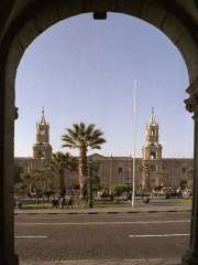
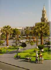
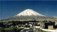
Fridays. Arequipa is the capital of the Province,
Department and Region of the same name. It is located at
Z230 meters (7,314 feet) a.s.l. it is the second largest
city of Peru. One of Its main attractions is the fact
that Arequipa has probably the nicest weather of Peru
with an average of 300 sunny days a year. The city keeps
its ancient architectural treasures, but also shows a
modern side with many luxurious hotels and casinos.
Arequipa gives tourists the opportunity to spend a
pleasant time in the city and its outskirts. It is also
the departing point for wider circuits. |
|
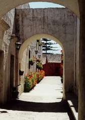
Once in the city, the Plaza de Armas,
the 'La Compañia de Jesus' church, which has cloisters
with ashlar (volcanic white stone or 'sillar") arcades,
and the renowned Santa Catalina Convent should not be
missed. On the outskirts of: the city some districts
stand out because of their beauty, like Cayma, which
temple was built in 1730, or Yanahuara, which belvedere
offers a great view of the city surrounded by volcanoes,
such as Chachani, 1,076 meters (3,529 feet) a.s.l.
Also important are the Yura Chapel, the San Lazaro
quarter the Sabandía Mill and the Añazhuayco quarries,
from where the ashlar ('sillar') is extracted. Arequipa
is known as 'La Ciudad Blanca" (White City) because of
the color of its ashlar buildings. |
 |
MEJIA LAGOONS
The Mejia Lagoons National Sanctuary is
located on the coast of Arequipa, near the mouth of the Tambo
river, 20 km (12.4 miles) south of the port of Mollendo and 150
krn (93 miles) from the city.
|
|
It is an isolated ecosystem and the
only vestige, between the north of Chile and
Pisco, of
the ancient flooded lands that were part of the American
coast, drained for agriculture for centuries. In spite
of being located at sea level and 170 S latitude, the
annual average temperature in the Mejía Lagoons is
usually 18º C (64.40 F), under the effect of the
Peruvian (Humboldt) warm stream.
The lagoons are separated from the ocean by a large
fringe of beaches and sandy pits. Within the protected
area (690 hectares/1,704 acres), several habitats are
grouped, including lagoons of different degrees of
salinity, salt marsh, reed patches, salt mines and wild
grass that form a complex ecosystem. This particularly
valuable scenario homes 157 bird species, of which 72
are residents, 62 are regular visitors and 24 sporadic
visitors.
Conservationist and investigation efforts are being made
today to entirely preserve this natural treasure. |
travel packages, Arequipa hotels reservations
and Arequipa tours to all the exciting destinations
AGUADA BLANCA AND SALINAS
Behind the Misti volcano, as seen from the
city, over an extensive plain at 4,000 meters (13,120 feet)
a.s.l. is the Aguada Blanca dam, declared a National Reserve. It
is a rather shallow and artificial lake originated by the Blanco
river containment. A little to the south, behind the Pichu Pichu
peak, is an even larger lagoon called Salinas. These lagoons are
a place for resting and nesting for a large population of birds
like the colorful flamingos. There is a strong migratory
relationship between these birds and the ones from Mejía, 180 km
(111.6 miles) from Salinas.
PAMPA CAÑAHUAS
Located at the Aguada Blanca National
Reserve, behind the Chachani peak. At about 4,000 meters (13,120
feet) a.s.I. this larger plain represents one of the best
habitats for the protection of vicuñas. a Peruvian camelid,
internationally known for its fine fleece. In Pampa Cañahuas,
these animals can be seen running completely free and, therefore,
without the shyness and apathy that seems to characterize them
under captivity.
THE COLCA VALLEY
To the north of Arequipa is the higher course
of the Colca canyon river valley which deep canyon is renowned among
rafters. The section previous to the canyon consists of an
encased valley that runs from east to west, beginning in the
cold puna and running down to warmer regions, showing its great
scenic beauty and cultural attractiveness.
COLCAS
One of the survival skills of the ancient
Colca people was the ability to store large amounts of grain for
hard times the warehouses, known as 'colcas', gave name to the
valley. In the 'cool' caves of Pumunuta, it is possible to see
circular colcas a meter (3.28 feet) in diameter, mad of mud and
straw.
|
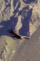 |
CRUZ DEL CONDOR
Usually, in such a deep valley, the rising winds are
surprisingly strong which big condors take advantage of
to soar into the sky easily.
Between Maca and Cabanaconde, where winds are even
stronger, is the Cruz del Condor, an observation point,
perfect for watching the condors while they fly
majestically. |
RAFTING ALONG THE COLCA-MAJES RIVER
From December to March, expert and trained
rafters can go along the high and middle section of the river,
explored by the 1979 Polish expeditions. It includes very
difficult and isolated rapids, as the towns are far from the
torrent. Although the low section may be ran over in rubber
rafts, only expert people, trained in kayac rafting can do it in
the canyon sections.
The name of the Colca river changes as it
flows down to the Pacific ocean, Past the canyon; its name is
Majes. Here, there are more chances for tourists to go in rubber
rafts. The chances of finding shelters and access ways are
better. Although its navigable section (Andamayo-Aplao river)
does not have long rapids, the beauty of landscape and the clean
river course allows enjoying the comfortable trip. The area is
open year round to visitors.
ETHNIC RICHNESS
An ethnic group, bearer of ancient and still
strong traditions, has dwelled the valley for more than 2,000
years. They are the Collaguas who arrived to the Colca valley
from the high regions and seem to be descendants of the Aymaras
because of their language and customs. Even under the Inca
dominion, they kept themselves relatively Independent, and
preserved their own traditions. It is sold that the supreme Inca
Mayta Capac married a Collagua princess in order to formalize
the conquest of the valley, and he built for her an elegant
country house made of copper, near Sibayo.
PETROGLYPS
The early settlers of the valley left their
own peculiar trace in petroglyphs such as Sumbay and Toro
Muerto. Dancers with bizarre headdresses, different mammals,
condors, and lines of unbreakable codes encompass the repertory
of vast figures.
CHURCHES
There are almost 20 towns along the valley,
which people preserve the ethnic richness of their past more
than any other region of the country. The main ones are Chivay,
Cabanaconde, Huambo, Maca, Achoma, Yunque, Larl and Coporaque,
all very religious towns, whose Catholic faith also keeps alive
pre-Columbian elements. Each town has its own church, bearer of
its Hispanic and an example of architectural sobriety and purity
based on the ashlar stone.
VALLEY OF THE VOLCANOES
Entering the -so called- 'Valley of the
Volcanoes" of Andagua means going back several geological eras
to witness some outstanding phenomena that only happen in two
places In the world: the Canary Islands and In this Arequipa
valley.
|
The Andagua river valley runs along
the foothill of the great Coropuna volcano, the highest
in Peru and the tenth highest in South America.
Geothermal activity In this area has given birth to
about 80 volcanoes, all of them extinct which give this
area a moonlike aspect. Later, the Andagua river
disappears in a 17 km (10.5 miles) stretch, running
under the ground between the Chachas and the Mamacocho
lagoons before flowing into the Colca. Andagua can be
reached only by highway from the west. |
 |
HOT SPRINGS
Because of the volcanic nature of the region,
there is hot springs in different areas of the valley. The main
ones are Yunque, Chivay, Callalli, La Calera, Huancarama, Yura
and Jesus. Furthermore, these hot springs are frequently related
to 'puquiales", natural sources of cold, extremely pure and 100%
potable water.
Spectacular airplane flights are available
allowing a unique and extraordinary view of the main attractions
of Colca, that can only be seen from the air. There are landing
strips in Huambo (in the canyon), Orcopampa (near the Volcano
Valley), Coporaque (the high part of the valley), Tiabaya, near
Arequipa and also from the city airport. |